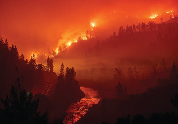
Consider the following summer extremes: In 2003 Europe’s worst heat wave in history killed more than 30,000 citizens. In 2010 wildfires in Russia and floods in Pakistan caused unprecedented damage and death. The 2011 U.S. heat wave and drought caused ranchers in Oklahoma to lose a quarter of their cattle. The 2016 Alberta wildfires constituted the costliest disaster in Canadian history. And the summer of 2018 that the U.S. experienced was notorious: temperatures flared above 100 degrees Fahrenheit for days on end across the desert Southwest, heavy rains and floods inundated the mid-Atlantic states, and California had a shocking wildfire season. Extreme heat waves, floods and wildfires raged across Europe and Asia, too.
Is it coincidence that the most devastating summer weather has occurred in recent decades? My colleagues and I do not think so. All these events had a striking feature in common: a very unusual pattern in the jet stream. The jet stream is a narrow band of strong wind that blows west to east around the Northern Hemisphere, generally along the U.S.-Canada border, continuing across the Atlantic Ocean, Europe and Asia. The band is sometimes fairly straight, but it can take on big bends—shaped like an S lying on its side. It typically curls northward from the Pacific Ocean into western Canada, then turns southward across the U.S. Midwest, then back up toward Nova Scotia. This shape usually proceeds west to east across the U.S. in a few days, bringing warm air north or cool air south and creating areas of rain or snow, especially near the bends. The jet stream controls our daily weather.
During the extreme events I noted, the jet stream acted strangely. The bends went exceptionally far north and south, and they stalled—they did not progress eastward. The larger these bends, the more punishing the weather gets near the northern peak and southern trough. And when they stall—as they did over the U.S. in the summer of 2018—those regions can receive heavy rain day after day or get baked by the sun day after day. Record floods, droughts, heat waves and wildfires occur.
On supporting science journalism
If you're enjoying this article, consider supporting our award-winning journalism by subscribing. By purchasing a subscription you are helping to ensure the future of impactful stories about the discoveries and ideas shaping our world today.
My collaborators and I have recently shown that these highly curved, stalled wave patterns have become more common because of global warming, boosting extreme weather. But we predict that the rising severity may level off for the next several decades. That may sound strangely “good”—the bad spells will continue, but at least they will not get worse. We also predict that the extreme events will start becoming much more severe, beginning around 2050 or so—particularly in summer. Threats to people’s health and safety will increase, storm damage will get more extensive and crops needed to feed a rising population will be ruined.
How do we know? Wave mathematics and quantum mechanics tell us. Yes—the mathematics that characterize the behavior of electrons at the smallest scale help us describe the behavior of our atmosphere at global scales. They indicate that the rise in dangerous weather, the coming plateau and the subsequent surge are driven by a curious trade-off between greenhouse gas concentrations from fossil-fuel burning and sulfur pollution from industrial smokestacks. And that trade-off raises the question of whether cutting emissions will prevent the jet stream from wreaking havoc.
Rossby brings bad weather
The jet stream forms where warm surface air from the subtropics around the globe moves northward and meets cold surface air from the polar region—roughly where the U.S. meets Canada. The jet blows at around 35,000 feet up, along the boundary between the troposphere (the lowest level of the atmosphere, where weather happens) and the stratosphere (the next level, where airliners fly).
The greater the temperature difference when the subtropical and polar air meet, the stronger the jet stream wind. During summer the temperature difference is less than during winter, so the jet stream is weaker. When it weakens, it is more likely to exhibit broad north-south bends.
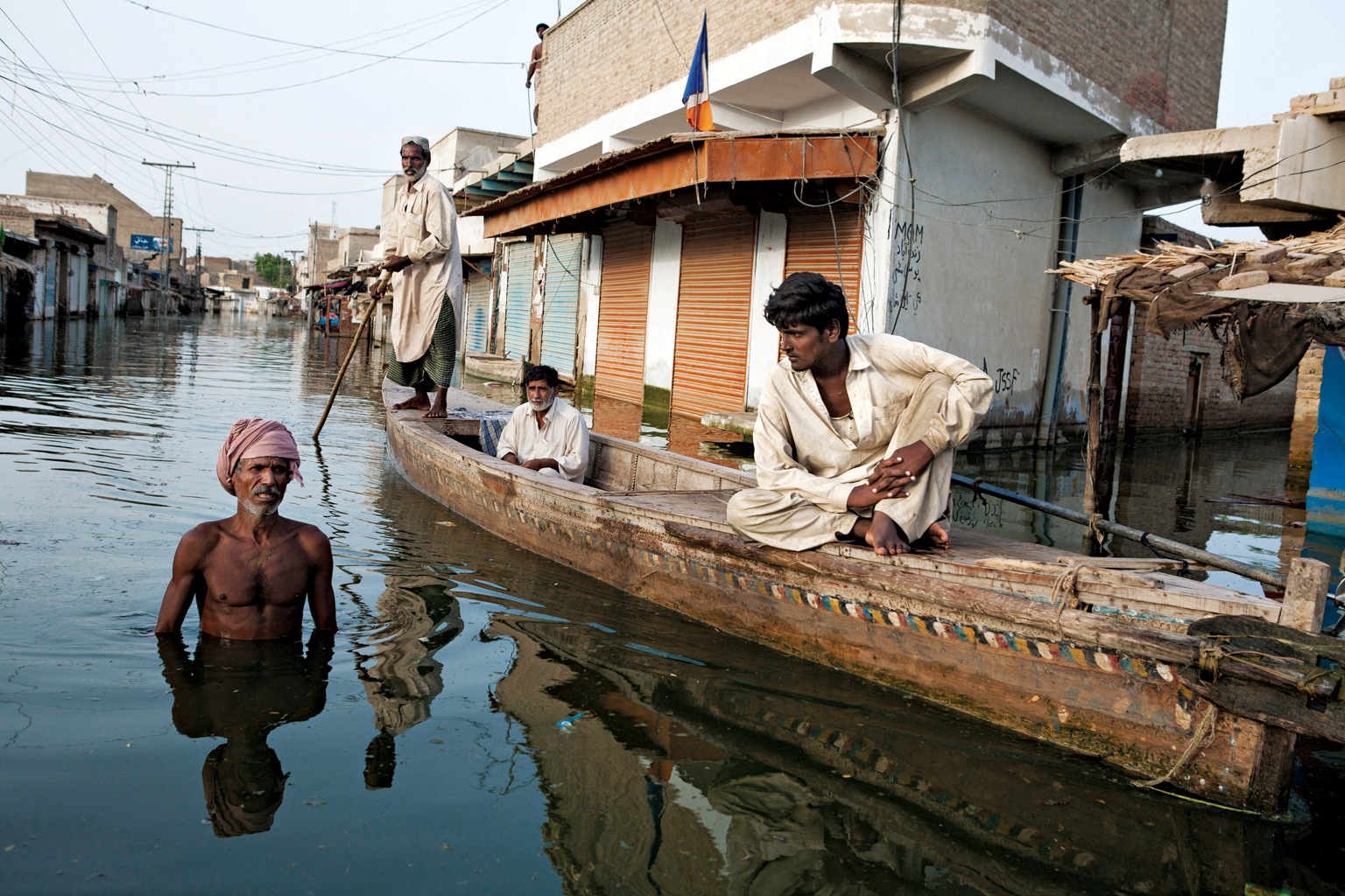
Deep floods caused by an atmospheric effect called quasi-resonant amplification submerged Khairpur Nathan Shah, Pakistan, in 2010. Credit: Gideon Mendel Getty Images
But why do the bends form where they do? The jet stream is affected by a set of large waves that waft through the atmosphere, created naturally as the earth rotates through a fluid—in this case, air. They are Rossby waves, named after Swedish-American meteorologist Carl-Gustaf Rossby, who first explained in the 1930s the physics of large-scale atmospheric motions. They occur throughout the oceans, too.
Rossby waves in the atmosphere extend for hundreds of miles and move west to east in the Northern Hemisphere. When the temperature difference between the air masses decreases in summer, the Rossby waves tend to bend more and proceed more slowly from west to east over North America. The jet stream follows the shape and path of those waves.
Other waves also course through the atmosphere and the ocean. For example, gravity waves arise from a temporary disturbance between gravity pulling the atmosphere down and buoyancy forces pushing it up, such as an air current passing over a mountain range. Kelvin waves occur in the Pacific in a tight corridor straddling the equator. There they travel predictably, west to east, periodically warming and cooling the surface waters, a key ingredient of the El Niño/Southern Oscillation climate phenomenon.
The bends in the jet stream create local surface weather systems that move eastward as the bends proceed that way. We see them on weather maps as the big H’s and L’s—high- and low-pressure systems. A high-pressure system tucked inside the northern bend, or ridge, rotates clockwise and in summer brings dry, hot weather. A low-pressure system tucked inside the southern bend, or trough, rotates counterclockwise, leading to wet, cool weather. If the jet stream is weak enough, the S-shaped Rossby wave it is tracking can stall in place, without proceeding eastward—a “standing wave” pattern. The high and low weather systems spin in place, persistently baking the earth below or barraging it with relentless rainstorms and flooding—what happened with Hurricane Harvey over Texas and Hurricane Florence over the eastern-central U.S.
Resonance makes it worse
Truly extreme weather tends to occur when the bends in the Rossby waves, and therefore the jet stream, are greatly amplified. The higher the ridges and lower the troughs, the deeper the high- and low-pressure systems. In this standing-wave pattern, the high-pressure system stagnates (sometimes called a blocking pattern). That is exactly what caused the July 2018 heat wave in the U.S. Southwest and simultaneous floods in the mid-Atlantic. Another classic example was the ridge over Russia in July 2010 associated with record heat, dryness and wildfires and, downstream of it, a deep trough over Pakistan associated with record flooding.
The amplitude that routine Rossby waves can attain is limited by the energy they radiate away as they bend north and south and as they proceed eastward. Under certain conditions, however, the atmosphere can act as a kind of waveguide. Imagine a west-east line across central Canada and another one across the southern U.S. A bent Rossby wave stays put, within these “walls,” losing little energy. This confinement locks in the curved jet stream and the strong high- and low-pressure systems.
The coaxial cable leading from your cable company to your television is an example of a waveguide. The electromagnetic waves that transmit the TV signal from it to you are largely confined within the cylindrical wall of the cable, and little of the signal’s energy is lost. Thank the physics of waveguides for the crisp images you enjoy.
When waves are stuck in place as standing waves, under certain circumstances the bends can grow readily in amplitude—what is known in physics as resonance. When this happens to Rossby waves, more common in summer, it is called quasi-resonant amplification, or QRA. Several years ago Vladimir Petoukhov and his collaborators at the Potsdam Institute for Climate Impact Research in Germany showed that the conditions supporting QRA depend on the shape of the jet stream. Climate change, it turns out, can impact the shape of the jet stream and thus QRA and the frequency of extreme summer weather events.
To understand how this confluence happens, we need to consult the same mathematics that was developed in the early 20th century to solve certain problems in quantum mechanics. That connection is particularly satisfying to me. I began my career in theoretical physics before moving into atmospheric science, so it is reassuring that those decades-old quantum mechanics textbooks I held onto are still useful in my work.
The quantum connection
Understanding how the behavior of an atmospheric wave is mathematically similar to the behavior of an electron will help reveal a key reason why droughts and floods are getting worse.
In classical physics, an electron can become trapped when it is surrounded by high potential energy. Imagine looking though a box from the side, with walls that are infinitely high. The electron cannot pass through the walls, because they have infinitely high energy that cannot be overcome. The electron bounces back and forth, left to right, in a straight line.
.png?w=1350)
Credit: 5W Infographics

Credit: Jen Christiansen
In the quantum mechanics picture, things are different. The electron no longer has a definite position. Instead the probability of finding the electron is determined by the famous Schrödinger equation, a wave equation. The motion of the electron—or more precisely, the probability of where the electron is most likely to be found—is described by a sinusoidal curve: an S laying down on its side. Sound familiar? The electron acts in part like a particle and in part like a wave.
Something interesting happens when the potential energy “walls” are not infinite in height but instead are finite. In that case, the electron has a small probability of actually penetrating the wall, and it can pass all the way through it if the wall is thin enough. It is as if you hit a tennis ball against a concrete wall, and it “tunneled” through the wall and out the other side. The same probability pertains to the opposite wall. The electron is largely confined to the box but with just a bit of “leakage” across the boundaries. Welcome to the peculiar world of quantum mechanics.
Looking through this finite box is the same as looking down the inside of a slightly leaky three-dimensional waveguide—like a coaxial cable. The mathematical nugget that allows us to solve the equations that describe these objects was put forward in 1926, known as the WKB approximation, after the three scientists who introduced it: Gregor Wentzel, Hendrik Kramers and Léon Brillouin. The WKB approximation is used in quantum mechanics for lots of wave equations and to aid the design of products such as the tunnel diode in your smartphone.
In the early 1980s David Karoly, now at Australia’s Commonwealth Scientific and Industrial Research Organization, and Brian Hoskins of the University of Reading in England demonstrated that the atmosphere can behave like a waveguide for stalled, or standing, Rossby waves that have certain short wavelengths (roughly the width of the continental U.S., or six to eight full wavelengths all the way around the Northern Hemisphere).
The standing Rossby wave becomes trapped inside the waveguide, with only minimal leakage of energy through the northern and southern boundaries—just like the electron. In this situation, the waves can grow in amplitude because of QRA. Stuck in place, the now huge standing wave creates extreme weather systems inside the ridges and troughs that persist for days. The WKB approximation, which leads to solutions to waveguide problems in quantum mechanics, also helps to solve the Rossby waveguide problem.
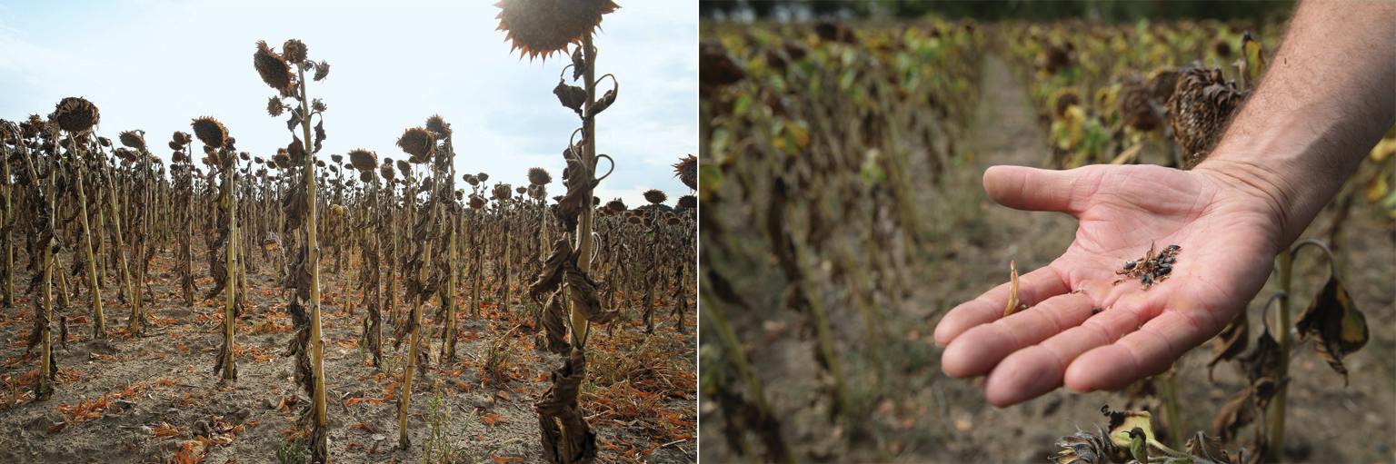
Parched sunflowers (left) and stunted seeds (right) near Golssen, Germany, were wrought by a prolonged heat wave in 2018. Credit: Sean Gallup Getty Images
A changing wave climate
With this understanding, we can now see how climate change is affecting the standing waves that give us persistent weather extremes. Several years ago Petoukhov and his Potsdam collaborators built on Karoly and Hoskins’s work, showing that waveguide conditions for standing Rossby waves arise primarily in summer. Often in summer, the jet stream is not a single, strong west-to-east wind. It alternates between two corridors, one to the north and one to the south of the typical location along the U.S.-Canada border.
Using the WKB approximation, Petoukhov’s group showed that it is precisely under these “double-peak” jet conditions that the atmosphere can behave as a waveguide for Rossby waves with a short wavelength. The amplitude of these waves is generally small: the bends do not extend very far north or south. But if an initial bend is generated when an air mass moving west to east hits the Rocky Mountains or the Alps or when it encounters a strong surface temperature contrast at the boundary between land and ocean, the Rossby waves can readily grow much larger bends through the QRA mechanism.
Whether conditions are favorable for QRA varies from year to year. They depend in large part on the north-south pattern of temperature variations in the lower atmosphere—something that climate models resolve well. In 2017 my colleagues and I showed that there has been a greater tendency in recent decades for conditions that favor QRA. Climate simulations show that the trend is driven by increases in greenhouse gas concentrations over time. Natural factors such as fluctuations in solar output and volcanic eruptions, as well as other human factors such as atmospheric sulfur dioxide pollution in particular, have also played a role. The simulations, called CMIP5, are the result of modeling by more than 50 groups worldwide done for the most recent report of the Intergovernmental Panel on Climate Change (IPCC).
Temperature data recorded at weather stations and the models show that climate change is causing the Arctic to warm faster than the rest of the Northern Hemisphere, a situation known as Arctic amplification. A smaller difference in temperature between midlatitudes and polar latitudes creates a slower jet stream overall, which favors more persistent weather patterns and is associated with the double-peak jet and QRA.
This mounting trend helps to explain the spate of long-lasting, extreme summer weather events seen around the Northern Hemisphere over the past two decades. Scientists have recently shown that QRA conditions are linked to the 2003 European heat wave, the 2010 wildfires in Russia and associated Pakistan floods, the drought that gripped Oklahoma and other parts of the U.S. in 2011, as well as wildfires in California in 2015 and the 2016 Alberta wildfires. Now we can add to that list the unprecedented California wildfires of 2018. Human-caused climate change has increased the likelihood of these excessive weather events by roughly 50 percent over the past few decades.
The stall
It sounds like extreme weather should just keep getting worse. And some basic factors suggest it will. For example, a warmer atmosphere holds more moisture, leading to more heavy rainfalls and flooding. And a warmer planet means more frequent, prolonged and intense heat waves. But what about the standing-wave jet stream and QRA?
As the great physicist Niels Bohr and subsequently baseball legend Yogi Berra are said to have remarked, predictions are hard—“especially about the future.” In a paper my colleagues and I published in October 2018 in Science Advances, we analyzed how QRA events are likely to change as a result of projected future climate change. We did indeed expect that the upward trend would continue unabated, but that is not what we found.
The IPCC and the CMIP5 experiments assess future conditions under different scenarios, everything from deep, immediate cuts in carbon dioxide emissions to a world that just keeps emitting more and more CO2 along the trajectory it has been taking. Under that so-called business-as-usual scenario, we found that the trend toward conditions favoring QRA flattens out until around 2050. Then it accelerates in the second half of this century.
The reason, we found, involves another important but sometimes overlooked human driver of climate change: atmospheric pollutants such as sulfur dioxide, which are produced by coal burning and other industrial activities. These pollutants form particulates known as aerosols that drift in the atmosphere and reflect sunlight back to space, cooling the earth below.
Aerosol pollution was responsible for acid rain from the 1950s to 1970s in the northeastern U.S. The Clean Air Act required industrial plants to install “scrubbers” in smokestacks to remove the sulfur dioxide from the emissions. That helped to save forests, lakes and streams, but it also left fewer aerosols in the atmosphere to reflect sunlight and counteract warming from rising CO2, one reason global warming has accelerated since the 1970s.
Much of the rest of the world—most important, China, which accounts for nearly half of all current coal burning—still employs old-style industrial practices. The IPCC business-as-usual scenario assumes that countries such as China will continue to burn coal, contributing to greater CO2 emissions that would more than triple the preindustrial level by the end of the 21st century. The scenario also assumes, however, that these industries will install scrubbers over the next several decades.
That will lead to a dramatic reduction in aerosols between now and midcentury—and much more warming. The effect is especially large in the midlatitudes during summer, when there is maximal sunlight; much of it will no longer be reflected. In some model simulations, the resulting midlatitude summer warming is so great that it exceeds the Arctic warming. Arctic amplification lessens or even stops. That would mean no increase or even a decrease in QRA—and no further worsening of the jet stream pattern behind the rise in extreme summer weather.
Destiny in our hands
Such a future seems like a good deal. But it is actually a Faustian bargain. The short-term mitigating effect comes at great long-term expense. By midcentury the aerosols are mostly gone, so from that point on, rising greenhouse gases continue to drive all temperatures up. Once again the rise becomes faster in the polar region. Arctic amplification resumes, and the QRA events—the stalled, intense, hot, dry and wet weather patterns—start increasing again. By the end of the century they rise by roughly 50 percent relative to now. The change will be most prominent in summer, in midlatitudes, which is especially troubling because that is where most people live and because that is where and when large quantities of crops grow—many of which do not hold up well in high heat.
Is there a way out? If the world acts now to quickly get off the business-as-usual treadmill and significantly lower carbon emissions, we can avoid a catastrophic two degrees Celsius (3.6 degrees F) warming of the planet, and we will most likely avert any additional increases in QRA events. The safest (and most cost-effective) path forward is to immediately curtail fossil-fuel burning and other human activities that elevate greenhouse gas concentrations.
It is worth noting that the world has to make decisions under uncertainty. Some simulations indicate much bigger (more than threefold) increases in QRA events, whereas others actually show decreases. The spread arises in large part from the different ways the climate models treat aerosols. Will the predictions converge? We do not yet know. Arguably, the wisest path forward, given the uncertainty and the huge potential risk if the worst-case scenario bears out, is to strongly reduce emissions.
Of course, it would be useful to reduce the uncertainties. Doing so comes down, at least in part, to the honing of physics. In this case, it is the physics of aerosols and their scattering of sunlight—the electromagnetic waves emanating from the sun. Once again this calls on understanding the physics of wave behavior. We have come full circle.